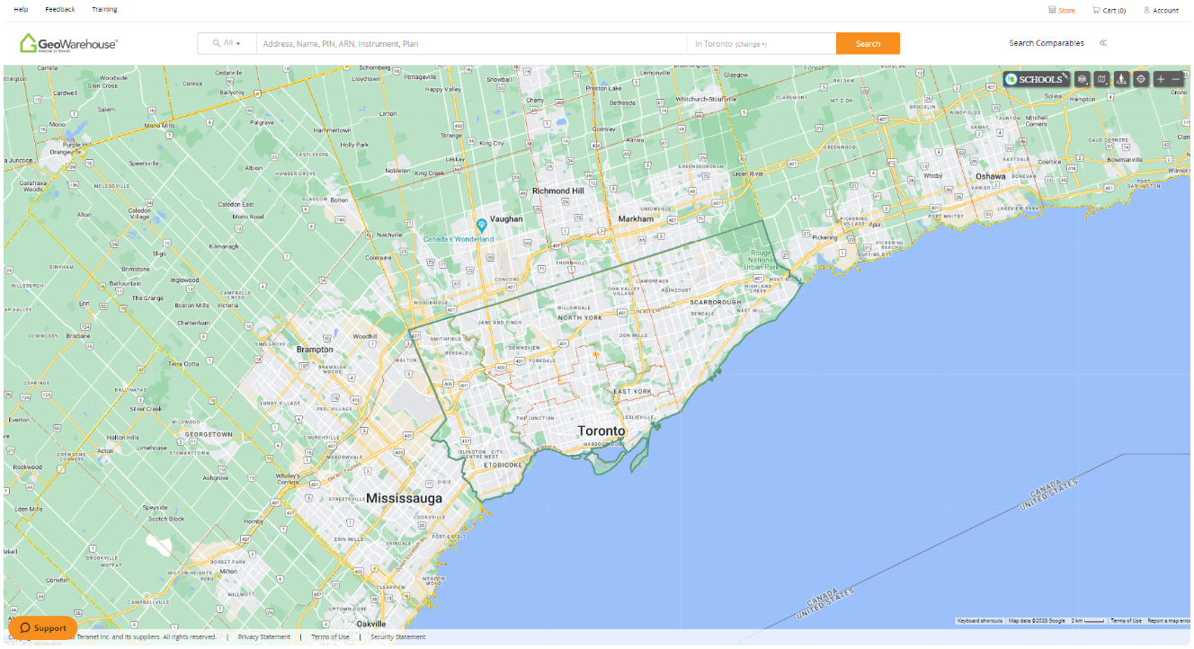
GeoWarehouse® is the single source of authoritative property information in Ontario. With the ability to verify ownership, create property detail reports, access to comprehensive neighbourhood sales and various demographics reports, GeoWarehouse subscribers have access to the critical property and land data they need to be successful.

Proven & Trusted
Reporting
GeoWarehouse® is the single source of authoritative property information in Ontario. With the ability to verify ownership, create property detail reports, access to comprehensive neighbourhood sales and various demographics reports, GeoWarehouse subscribers have access to the critical property and land data they need to be successful.

Solutions That Suit Your Needs
Building and developing
Building & Developing
Make informed decisions on your next project with critical land and property data
ExploreLaw and investigation
Law &
Law &
Investigation
Obtain critical property and land information to assist in your investigations
ExploreWhat is GeoWarehouse?
GeoWarehouse is the authoritative web-based centralized property information platform. With its state-of-the-art mapping and complete data source for all real estate transactions, research tools, as well as a range of professional reports, GeoWarehouse revolutionizes the way you access and analyze land and property data in Ontario.
Discover the GeoWarehouse Store, where subscribers can conveniently explore a wealth of resources for purchase to assist with due diligence as all the essential land and property information you need is just a click away.
Equipped with GeoWarehouse, you’ll have the tools at your fingertips to become the go-to expert in your field.

30
Years in land registration

7000000
Properties available for search in Ontario

100000
Canadian users that trust us
30
Years in land registration
7000000
Properties available for search in Ontario
100000
Canadian users that trust us
What is GeoWarehouse?
GeoWarehouse is the authoritative web-based centralized property information platform. With its state-of-the-art mapping and complete data source for all real estate transactions, research tools, as well as a range of professional reports, GeoWarehouse revolutionizes the way you access and analyze land and property data in Ontario.
Discover the GeoWarehouse Store, where subscribers can conveniently explore a wealth of resources for purchase to assist with due diligence as all the essential land and property information you need is just a click away.
Equipped with GeoWarehouse, you’ll have the tools at your fingertips to become the go-to expert in your field.
30
Years in land registration
7000000
Properties available for search in Ontario
100000
Canadian users that trust us
30
Years in land registration
7000000
Properties available for search in Ontario
100000
Canadian users that trust us
Why Choose GeoWarehouse?
Discover how GeoWarehouse helps you work smarter with instant access to the most comprehensive and authoritative property data and title intelligence. This quick video shows how an annual subscription can help you save time, reduce risk, and make better-informed decisions using the same reliable data trusted by government and industry leaders throughout Ontario.
Get Access to
Basic Client Report
This report includes an aerial and street view of the property and the details pertaining to the land including lot size.
My Property Report
This all-in-one completely customizable report contains valuable information that includes property ownership and sales history data, imagery of the subject property, estimated market value, and more.
Client Property Report
This customizable report includes private data such as legal description, owner names, market information and comparable sales data. The Client Property Report also includes historical trends, average sales value, market turnover and more.
Comparables Report
This report enables you to review comparable sales in a particular area. You can perform a search by radius, date of sale, and price range.
Interactive Heat Maps
The interactive heat map tool, featuring three layers of data, quickly and accurately displays real estate transaction information for any market in Ontario.


GeoWarehouse Store
The GeoWarehouse Store is an online store exclusively available to GeoWarehouse customers. It offers professionally packaged reports to help you become the property expert. The GeoWarehouse Store offers a host of products that enable you to perform a comprehensive property search. It is your virtual connection to relevant information such as property ownership history, instrument images, surveys, plans, and other vital data that could make or break your deal.
Learn More

GeoWarehouse
Store
The GeoWarehouse Store is an online store exclusively available to GeoWarehouse customers. It offers professionally packaged reports to help you become the property expert. The GeoWarehouse Store offers a host of products that enable you to perform a comprehensive property search. It is your virtual connection to relevant information such as property ownership history, instrument images, surveys, plans, and other vital data that could make or break your deal.
Learn More
Additional Analysis Tools
The following additional reports, available for purchase in the GeoWarehouse Store, provide the insight you need to complete your due diligence.

Additional Analysis Tools
The following additional reports, available for purchase in the GeoWarehouse Store, provide the insight you need to complete your due diligence.
Parcel Register*
This powerful transactional report provides an in-depth look at a property’s history, including ownership, transfers, encumbrances, liens, and more.
Property Insights Report with AVM Range
Access all property information, including a trusted valuation using Teranet’s AVM, helping support CMA development with a secondary unbiased opinion.
Enhanced AVM Comparable Report
This report provides insights into comparable sales in proximity to the subject property, including sales by owner, exclusive sales, builder sales and more.
LandLogic Zoning Reports
Get the zoning information you need. The Basic Zoning Report gives a quick snapshot for early-stage due diligence, while the Enhanced Zoning Report delivers everything in the Basic Report, plus deeper, address‑specific analysis.
Parcel Register
This powerful transactional report provides an in-depth look at a property’s history, including ownership, transfers, encumbrances, liens, and more.
Property Insights Report with AVM Range
Access all property information, including a trusted valuation using Teranet’s AVM, helping support CMA development with a secondary unbiased opinion.
Enhanced AVM Comparable Report
This report provides insights into comparable sales in proximity to the subject property, including sales by owner, exclusive sales, builder sales and more.
LandLogic Zoning Reports
Get the zoning information you need. The Basic Zoning Report gives a quick snapshot for early-stage due diligence, while the Enhanced Zoning Report delivers everything in the Basic Report, plus deeper, address‑specific analysis.


GeoWarehouse Success Stories

GeoWarehouse Success Stories
Harness GeoWarehouse to Complete Your Due Diligence
Apply for your GeoWarehouse subscription by completing the form.
Harness GeoWarehouse to Complete Your Due Diligence
Apply for your GeoWarehouse subscription by completing the form.
Maximize your subscription

Maximize Your Subscription
Register for an upcoming training session.
Have a Question?

Have a Question?
Contact one of our customer support representatives.
Explore the GeoWarehouse Blog


Become an Insighter
At Teranet, we are dedicated to offering you the products and solutions that are beneficial to you in your business. To ensure we are evolving alongside you and your business, we launched the Teranet Insighters Community, which offers you the opportunity to share your voice and valuable feedback.
Help shape the future of our products and services by becoming a member today.
Our Partners