GeoWarehouse® is an invaluable tool for developers, architects, builders, engineers and other professionals in the industry. It provides a wealth of information and data that is crucial for making informed decisions and ensuring successful project outcomes. With its comprehensive range of features and user-friendly interface, GeoWarehouse streamlines the process of gathering, analyzing, and utilizing geospatial information.
Building & Developing
Select your profession to learn more:


GeoWarehouse +
Engineering
GeoWarehouse is an invaluable tool to any engineering firm as it provides data, analytics, and insight they can leverage to assist their clients.
Book A DemoGeoWarehouse +
Engineering
GeoWarehouse is an invaluable tool to any engineering firm as it provides data, analytics, and insight they can leverage to assist their clients.
How Engineers Use GeoWarehouse
Access to Parcel Boundaries and Land Data
GeoWarehouse is a powerful platform that provides engineers with access to extensive property information, including accurate parcel boundaries, zoning details, land use data, and more. By leveraging this wealth of geospatial information, engineers can conduct thorough site analyses, assess environmental factors, identify potential constraints, and optimize designs accordingly.
With its robust capabilities and user-friendly features, GeoWarehouse has become an indispensable tool for engineers, empowering them to create innovative solutions and deliver successful projects across various domains, from infrastructure development to urban planning and beyond.
Reports to Leverage
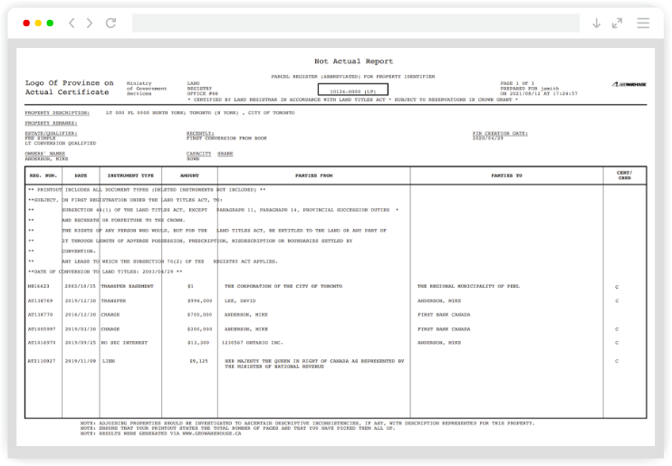
Parcel Register*
A record containing property description and list of instruments registered against the property within the Land Registration System of Ontario as of the date of search. A real-time report for a property. The provincial ownership records. Exercise due diligence by identifying registered encumbrances and acquire an instrument number.
*An official product of the Ontario government pursuant to provincial land registration statutes.

Schedule Your Private Demo
Discover how GeoWarehouse streamlines planning, reduces risk, and supports confident decision-making in a personalized demo. With GeoWarehouse, engineers gain access to critical property data for smarter site assessments and design decisions. Book now.
Book Now
Schedule Your Private Demo
Discover how GeoWarehouse streamlines planning, reduces risk, and supports confident decision-making in a personalized demo. With GeoWarehouse, engineers gain access to critical property data for smarter site assessments and design decisions. Book now.
Harness GeoWarehouse to Complete Your Due Diligence
Apply for your GeoWarehouse subscription by completing the form.
Harness GeoWarehouse to Complete Your Due Diligence
Apply for your GeoWarehouse subscription by completing the form.
Maximize your subscription

Maximize Your Subscription
Register for an upcoming training session.
Have a Question?

Have a Question?
Contact one of our customer support representatives.
Explore the GeoWarehouse Blog


Become an Insighter
At Teranet, we are dedicated to offering you the products and solutions that are beneficial to you in your business. To ensure we are evolving alongside you and your business, we launched the Teranet Insighters Community, which offers you the opportunity to share your voice and valuable feedback.
Help shape the future of our products and services by becoming a member today.
Become an Insighter

At Teranet, we are dedicated to offering you the products and solutions that are beneficial to you in your business. To ensure we are evolving alongside you and your business, we launched the Teranet Insighters Community, which offers you the opportunity to share your voice and valuable feedback.
Help shape the future of our products and services by becoming a member today.