With the COVID-19 pandemic ongoing, it’s critical for Canadians to maintain public health guidelines, such as social distancing — even in the real estate industry.
However, this poses a problem for tasks that traditionally require close contact, such as securing images of a property.
Unless the property was already on the market before the COVID-19 pandemic or is unoccupied by tenants, it could be difficult to get photos — both for showing and for appraisal.
Some solutions can help reduce this challenge. The key lies in your technology…
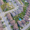
- Aerial Images
When you access a GeoWarehouse Property Report, you instantly gain access to a trove of information about the property (or properties) you’re considering.
On the Overview tab of your Property Report, you can view high-level property information, including the lot size with measurements from MPAC.
The Site & Structure section the Report includes even more information — including a detailed satellite and map view of the property, lot size, and site dimensions.
When you expand the satellite map, you zoom in and out to adjust the view. You can also refine your view using Map View and Map Layers. The satellite map displays approximate measurements and you can also take approximate measurements within the map — for example, if you wanted to measure only the length or depth of the driveway or a neighbouring property.
Watch our Property Report video for more information: https://vimeo.com/281616142
- Street View Images
You may not necessarily have an exact address in mind but want to search an area.
Or, perhaps you want to view a property up close, confirm the address, and more.
When you need close-up images of a property, you can use Street View, which accesses images from Google Maps. The advantage of viewing these images within GeoWarehouse is that you can also view property information details at the same time.
You can pan and explore a street or a neighbourhood, zoom in to verify the property address if it is visible, and access a comprehensive Property Report that includes further images and information about the property.
This can also give you a bird’s eye view of the area.
Learn more about Map View and Street View in our video: https://vimeo.com/194089066
- Property Plans and Surveys
You can also find registered plans and private surveys associated with a property, if available, and purchase the official documents.
From here, you can purchase further aerial imagery with a parcel overlay in the GeoWarehouse e-Store.
This can give you even more details and is particularly useful if you or a client is seriously considering a property.
The Property History section of your Property Report can also tell you whether a property has been split, consolidated, or re-entered previously.
- Neighbourhood Analytics
In addition to viewing property images, you may also want more information about a neighbourhood as a whole.
Pre-COVID-19, you might have driven around a neighbourhood to gauge this, but with social distancing in effect you can do this without leaving the house at all (not to mention, save a lot of time).
For instance, while the property itself is often a big selling feature, many clients also have preferences about nearby schools, parks, or transit locations.
You might also want to find demographics information about the neighbourhood — what is the total population? The age range? The total number of occupied dwellings? And so on.
This information can also be found online:
- The Demographics section in your Property Report or specific Neighbourhood Report from GeoWarehouse can tell you pertinent information about who lives in the neighbourhood.
- The new HoodQ Report integrations in the GeoWarehouse e-Store highlight school catchment zones, parks & rec, safety and convenience, transit locations, and more.
Between these two reports, you can gain a wealth of information — from the comfort of your home.
This is certainly not an easy time for anyone, but these tools can make it a little less of a challenge — and ensure you have access to relevant information while maintaining safety for both you and your clients.
What types of images and property information are you searching for right now? Let us know on social media. GeoWarehouse is on Twitter, Facebook, and LinkedIn.
Learn more about our comprehensive property reports, aerial imagery, and other solutions at www.geowarehouse.ca.
Stay up-to-date on the latest Teranet updates in our COVID-19 Information Centre: https://www.teranet.ca/teranet-news-categories/covid-19-information/