Technology is a trusted ally for law enforcement professionals. When every second counts, having reliable, data-driven & property intelligence tools at your fingertips is the key to staying ahead in the fight against crime.
At Teranet, we understand technology’s critical role in modern law enforcement. That’s why we’re excited to announce that GeoWarehouse will be returning to the Ontario Association of Chiefs of Police (OACP) & Blue Line Expo on April 29, 2025, at The International Centre in Mississauga, Ontario, where we will once again showcase our industry-leading property data solutions.
As part of our commitment to empowering law enforcement with unparalleled access to land registry information and property intelligence tools, GeoWarehouse continues to play a critical role in accelerating investigations, detecting fraud, and providing actionable insights that help law enforcement professionals stay one step ahead.
The evolution of law enforcement technology
Law enforcement technology has come a long way, and it continues to evolve at a rapid pace. From handwritten reports and manual record-keeping to the digital age of data analytics, the transformation has been incredible.
The challenges faced by law enforcement have also grown in complexity. Today, investigators are handling an unprecedented volume of data and information. Criminals have become more sophisticated in their methods, requiring innovative solutions to keep up. That’s where GeoWarehouse comes in.
A strategic edge for law enforcement
GeoWarehouse revolutionizes data access and analysis for law enforcement professionals. It provides them with property intelligence tools and technology needed to navigate the intricate web of modern crime.
With GeoWarehouse, law enforcement officials can access accurate property information, ownership records, historical sales data, search by name and much more – exclusively sourced from the Government of Ontario’s official land registry.
Armed with this level of detail, law enforcement officials can make informed decisions, detect real estate fraud patterns and accelerate various types of investigations. More than just a property intelligence tool, GeoWarehouse, then, becomes a strategic advantage that leads to more successful outcomes in their efforts to protect and serve the community.
Features built for speed and accuracy
GeoWarehouse offers a host of features tailored for law enforcement:
- Identifying fraud: GeoWarehouse enables law enforcement to identify patterns indicative of fraudulent behaviour, particularly in mortgage-related cases. By analyzing the most recent sales history and utilizing the Property Insight Report, officials can scrutinize a property’s complete list of sales transactions, including registration date, and consideration value.
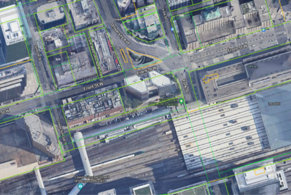
- Research: GeoWarehouse provides law enforcement professionals with advanced imagery tools, including ortho and streetview, allowing them to conduct thorough research on subject property premises. This feature facilitates virtual reconnaissance, enhancing the investigative process and aiding in the gathering of critical evidence including the identification of outbuildings.
- Ortho vs. Streetview: What’s the difference? Ortho imagery is aerial photography that removes distortion from terrain, sensors and cameras, ensuring uniform scale for precise measurements and mapping. Streetview imagery offers ground-level panoramic street views, captured using vehicle-mounted cameras, facilitating virtual navigation, property exploration and visual inspections.
- Identification: GeoWarehouse’s extensive database enables law enforcement officials to confirm property ownership and identify past owners through searching by name, which is especially valuable in investigations related to property disputes, asset tracking and historical ownership records. By searching for property ownership in various Land Registry Offices (LRO) and cross-referencing data to confirm details such as date of birth on government documents through POLARIS (Province of Ontario Land Registration Information System), GeoWarehouse ensures accuracy and reliability in asset identification. This streamlined process not only expedites investigations but also facilitates the efficient collection of documentation necessary to secure warrants with confidence.
Actionable insights to aid investigations
GeoWarehouse offers a variety of reports to support investigations:
- Aerial Imagery: This tool enables users to purchase high-quality aerial imagery for various purposes, including formulating tactical plans to visit the premises. It provides coverage for all of Southern Ontario, including areas not typically available in many commercial mapping platforms with various options to view canopy on and canopy off, allowing visibility of outbuildings. With photos available at three zoom levels, investigators can gain valuable insights into properties of all sizes.
- Parcel Register: This official provincial ownership record report provides a detailed property description and lists all instruments registered against the property within the Land Registration System of Ontario as of the search date. It serves as a real-time snapshot of property ownership records, allowing investigators to exercise due diligence by identifying registered encumbrances and acquiring an instrument number.
- Instrument Image: This feature offers an image of a registered land title document within the Land Registration System of Ontario, which may include liens, mortgages, transfers, and condominium declarations, among others.
Join us in Mississauga!
We’re thrilled to be an exhibitor at this year’s OACP & Blue Line Expo in Mississauga, and we hope to see you there! It’s your chance to gain valuable insights, network with peers and explore the latest technology solutions for law enforcement professionals.
Visit our booth to see live GeoWarehouse demonstrations and interact with our experts. RSVP here for free to gain priority access to our team.
If you’re unable to attend the event, we would be happy to show you how GeoWarehouse data solutions can help your team at a later date. Book a private demo here.